Updated Ontario Line plans to maximize space alongside GO rail
The Ontario Line will deliver transit to east of the Don River, with a bridge to downtown.
Sep 29, 2020
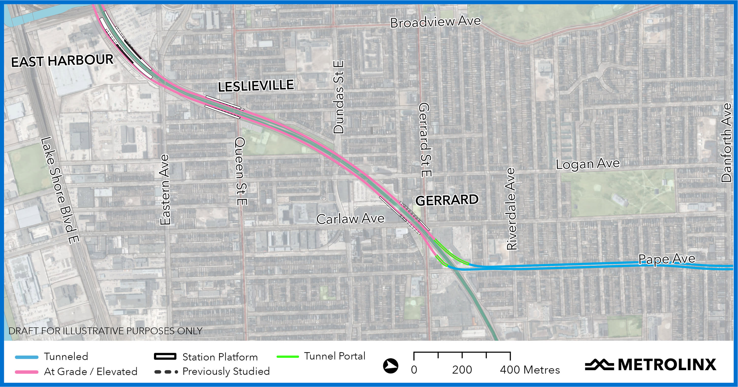
Twin bridges over the Don River and an efficient track alignment that stays largely within the existing GO rail corridor – without touching the Jimmie Simpson Recreation Centre – highlight a package of new details for the East segment of the Ontario Line, released today by Metrolinx.
The details are meant to keep communities informed and seek residents’ feedback.
The route will take advantage of the GO rail corridor, moving above ground from the Don Yards (where our last story left off) before dipping underground at Gerrard and Carlaw to connect with the Line 2 subway at Danforth and Pape and continue northward.

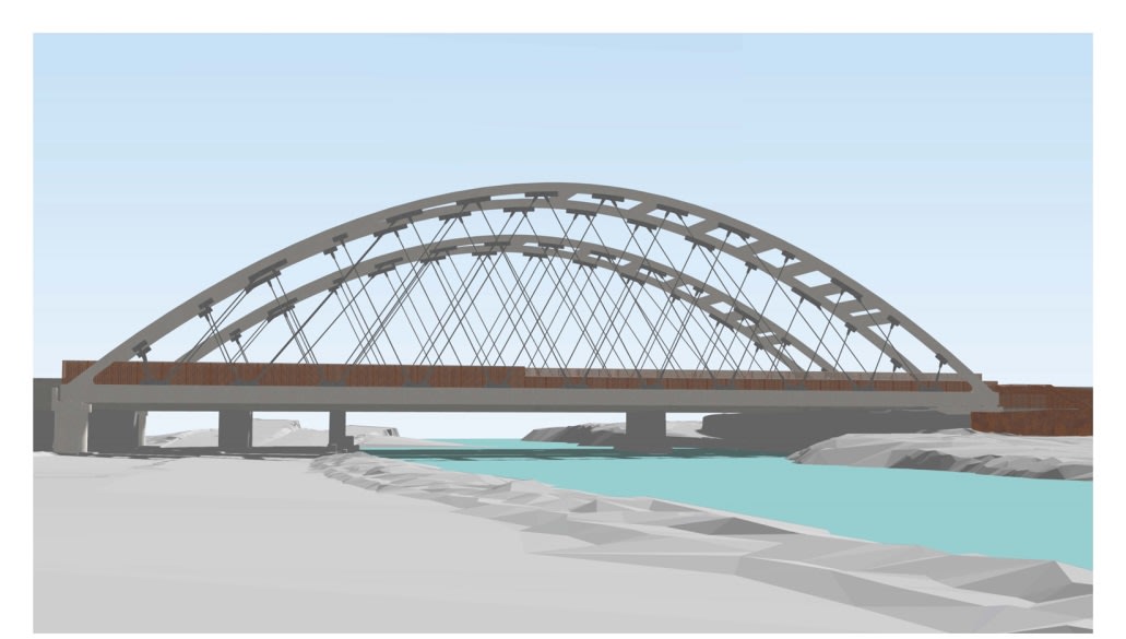
The Ontario Line will cross the Don River with two bridges, flanking the existing rail bridge, with space for tracks going in both directions. (Metrolinx image)
This above-ground section will welcome passengers easily with accessible stations, at or just above ground level, and whisk them quickly to their desired destinations. The existing corridor provides an efficient use of resources, making it possible for Metrolinx to deliver more rapid transit to more people with a 15.5-kilometre route at only a slightly higher cost than to the previous Relief Line South proposal, which was less than half the length.
Since last April, when the above-ground section was first unveiled, a big focus for Metrolinx has been determining how it could bridge over the Lower Don River in a way that would benefit the surrounding neighbourhoods and respect Aboriginal treaty rights in the area. The plans released today propose how that could be done.
"“Two new bridges will provide an iconic look, similar to the current Humber Bay Arch Bridge, giving Toronto east and west structures that will match up as bookends.”"- Damien Forbes, a Metrolinx Project Manager for the Ontario Line.
Today’s plan proposes two bridges, flanking the existing rail bridge, with space for tracks going in both directions.
The current plan for this area is to also provide pedestrian and cycling connections across the Don River to ensure communities continue to develop and thrive with improved transit.
The team at Metrolinx is taking care to make sure the bridges are an attractive addition to the neighbourhoods they will serve and to ensure all Aboriginal and treaty rights are respected. As well, they will serve as a gateway to downtown, instantly joining the Bloor Viaduct and Queen Street Bridge as recognizable landmarks on the Don River.
“Our approach to infrastructure design focuses on structures that are clean, simple, functional and elegant,” said John Potter, Design Standards manager for Metrolinx “What will make these new bridges stand out is the fact that there will be two parallel structures that will always be seen together.
“As part of our detailed design process, we will want to keep the Lower Don bridges simple to avoid unnecessary visual noise that can be amplified by doubling up of the structures.”
For design inspiration, the team looked across the city.
“Two new bridges will provide an iconic look, similar to the current Humber Bay Arch Bridge, giving Toronto east and west structures that will match up as bookends,” said Damien Forbes, a Metrolinx Project Manager for the Ontario Line.
Efficiently bridging over the Don River saves money and removes the engineering challenges, environmental risks and potential impacts to Aboriginal and treaty rights associated with building a massive tunnel underneath both the river and its floodplain. Ultimately, the design of these bridges will be the subject of further consultations with communities and stakeholders including Indigenous communities.
Just east of the Don River and north of Lake Shore Boulevard, a station at East Harbour will accommodate both GO train and subway service in a corner of the city that is poised for growth.
In many cases, people transferring from a GO train to the Ontario Line will be able to walk straight from one to the other without having to go up or down a level. That’s an improvement over the Relief Line South proposal, which needed very deep tunnels — 38 metres below ground — to reach underneath the Don, adding four-and-a-half minutes of escalator time to each transfer.
From there, the Ontario Line will continue through the GO corridor to the new station serving Leslieville and Riverside, bridging above and extending south from Queen Street East.
This station will provide faster transit into the downtown core for residents in the surrounding neighbourhoods who currently use the Queen streetcar.
“It will be an important transfer point for westbound riders to pop off the streetcar and get on the subway,” said Andre Marois, Director Corridor Infrastructure at Metrolinx.
Riders will access the station through entrances along Queen, minimizing impact to Jimmie Simpson Park, while improving transit access to this important community asset.
The updated plan adds three tracks (two for Ontario Line and one for GO expansion) while staying almost exactly within the current GO corridor footprint.
“The map shows the line beside the Jimmie Simpson Recreation Centre without disturbing it,” said Malcolm MacKay, Metrolinx Program Sponsor for the Ontario Line.
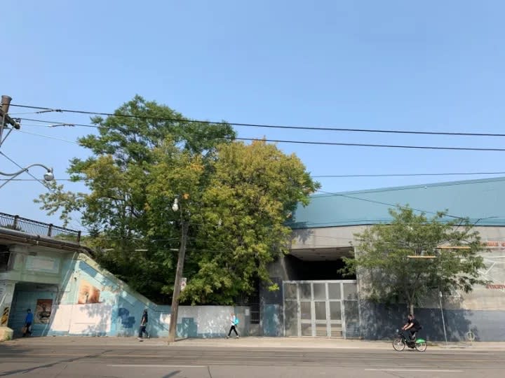
While the existing GO Rail corridor comes very close to Jimmie Simpson Community Centre, Metrolinx has a plan to add two new tracks to the Ontario Line without touching the building. (Mike Winterburn photo)
It’s fair to ask how three more tracks can fit in that space, and the answer is rooted in the neighbourhood’s history as a railway hub.
The new station will be just south of the Grand Trunk Railway’s Riverdale Railway Station, which was built in 1896 and is now commemorated with a plaque on Queen facing De Grassi Street.
The old station’s platform took up space between the tracks that now sits unused in the GO corridor.
“As we started designing, we weren’t sure if we were going to be able to use that extra-wide spacing of the GO tracks, but we needed to look into the feasibility of doing so because we know how important the recreation centre is to the community,” said Marois.
And that extra work was successful.
Under the updated plan, when new tracks are installed as part of the Ontario Line and GO expansion projects, Metrolinx will take full advantage of that area, staying almost exactly within the existing footprint. It is not a perfect fit, but it is very, very close.
“We are maximizing our use within the GO property but some tiny slivers outside the current corridor boundaries will be impacted in the final buildout,” said MacKay. “In most places, it will be as little as a foot.”
The new alignment preserves a Riverside institution, the Bonjour Brioche bakery.
“From Eastern Avenue to Gerrard Street, we’ve been able to optimize the track alignments and minimize impacts,” Marois added.
He went on to compare the use of space around Queen to similar plans for the rail bridge over Dundas Street. The new plan for that bridge will reduce impacts on properties around Dundas and Logan.
Another important addition to the Lakeshore East GO corridor, to support the surrounding neighbourhoods, will be new noise walls.
Metrolinx is committed to building noise walls along this shared railway, where the Ontario Line will run alongside the GO tracks. Noise walls will be effective in significantly reducing noise from Ontario Line, GO and VIA vehicles.
The exact locations and heights of noise walls will be confirmed as design work continues, and Metrolinx will of course continue to engage communities and seek feedback on those designs and other mitigation measures throughout the course of the project.
Positioning for a station near Gerrard Street and Carlaw Avenue, where the GO corridor meets the intersection, has also been refined.
The new plan features slight shifts to both the station and the portal, through which trains will go underground, reducing impacts on residential property. Much of the space to be used for the portal and construction is currently paved over for parking. Metrolinx will work with local business owners to minimize the impacts of construction on their properties.
The tunnel (or tunnels) will run under a small corner of the Pape Avenue Junior Public School. The property will be protected, with access maintained throughout construction.
From the portal, just north of Gerrard, trains will proceed underground to a new station just north of Danforth Avenue, at the TTC’s Pape station, where it will meet the Line 2 (Bloor-Danforth) subway. The connection will relieve crowding on Line 1 by delivering a faster route to downtown.
Next week, we will follow the North section of the Ontario Line, from the Danforth towards a new transit centre on Eglinton Avenue East, at the Ontario Science Centre.
For more details, you can visit the Ontario Line Metrolinx Engage website, where Metrolinx will continue to share updated project information. You can share your views, comments and suggestions on this two-way engagement hub throughout the entire duration of the project.
The map in this story was updated on Oct. 6, 2020.
by Mike Winterburn Metrolinx communications senior advisor