How design alternatives and pinch points are evaluated.

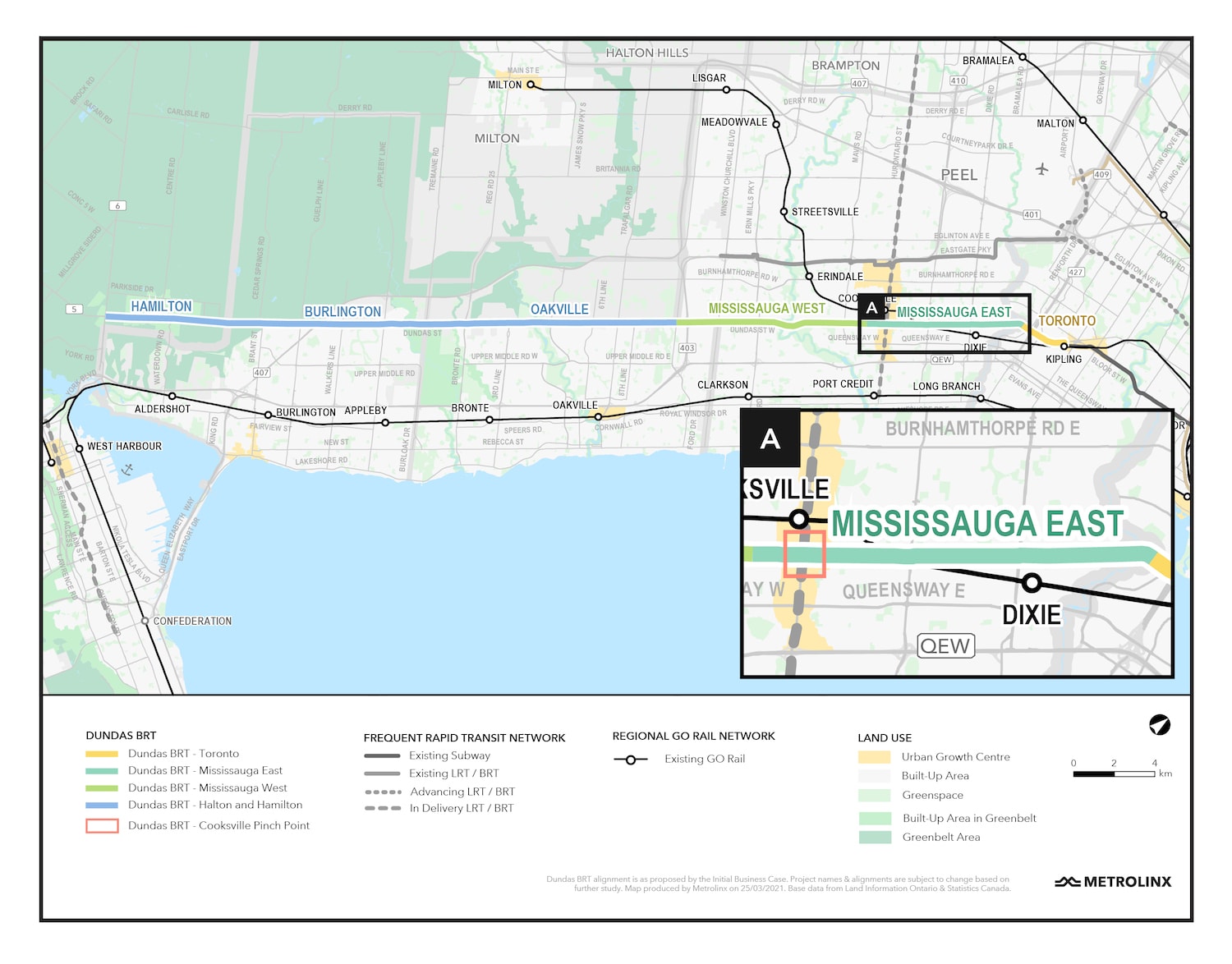
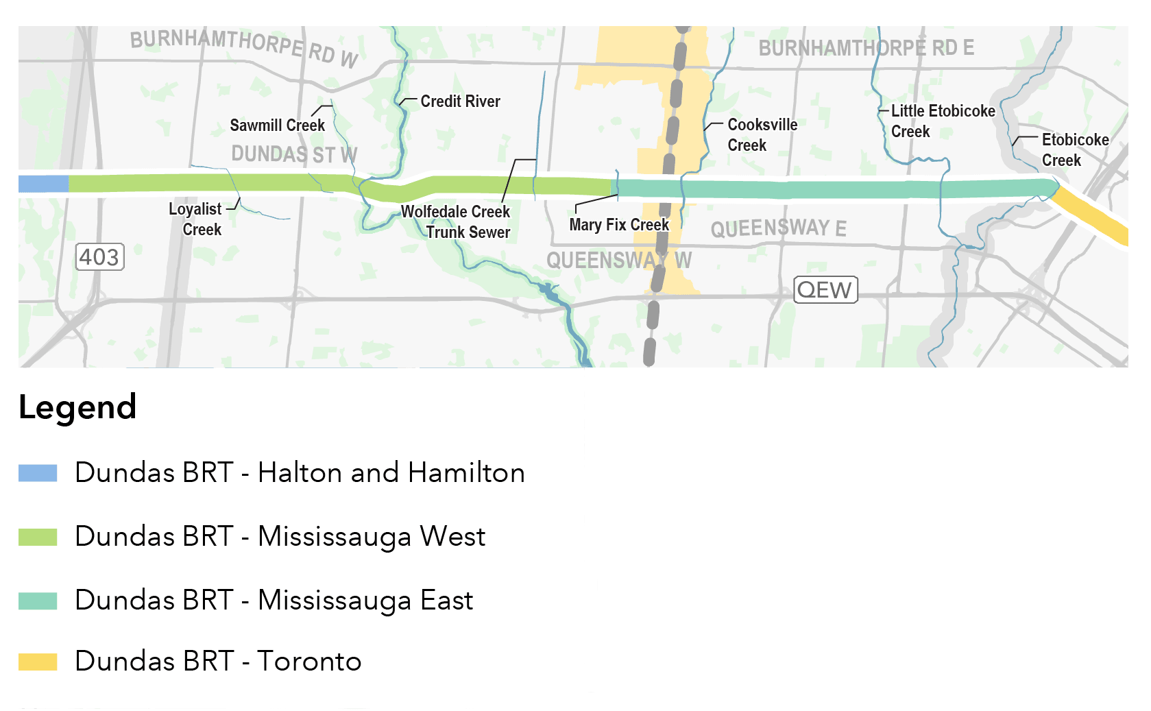
Dundas BRT
Environmental Project Report update
Mississauga East Reports
The Environmental Project Report (EPR) was available for a 30-day review period from February 23, 2022 to March 25, 2022. On April 27, 2022, the Minister of the Environment, Conservation and Parks issued a Notice to Proceed with the municipal transit project in accordance with Ontario Regulation 231/08. As the final step of the Transit Project Assessment Process (TPAP), Metrolinx and the City of Mississauga have issued a Statement of Completion in accordance with Ontario Regulation 231/08. We have also made available, online, our revised Environmental Project Report (EPR), EPR Errata, and revised Stage 1 Archaeological Assessment.
Mississauga West and Toronto Reports
When the TRPAPs are completed for Mississauga West and Toronto, the reports will be posted on this page.
Environmental Project Report (EPR)
Environmental Project Report (EPR)
Appendix A: Figures
Appendix B: Design Criteria Report
Appendix C: Dundas Bus Rapid Transit - Mississauga East Design
Appendix D: Technical Reports (all)
- Air Quality Impact Assessment Report
- Draft Arborist Report
- Climate Change and Sustainability Report
- Cultural Heritage Evaluation Report - 202 Dundas Street West
- Cultural Heritage Evaluation Report - 196 Dundas Street West
- Cultural Heritage Evaluation Report - 51, 55-57 Dundas Street West
- Cultural Heritage Evaluation Report - 47 Dundas Street West
- Cultural Heritage Evaluation Report - 37 Dundas Street West
- Cultural Heritage Evaluation Report - 14, 20-38 Dundas Street East
- Cultural Heritage Report: Existing Conditions and Preliminary Impact Assessment
- Limited Phase I Environmental Site Assessment Report
- Environmental Project Report
- Noise and Vibration Impact Assessment Report
- Socio-Economic and Land Use Study
- Stage 1 Archaeological Assessment
Appendix E: TPAP Engagement Process & Correspondence (all)
- Project Distribution List
- Engagement Summary Reports
- Pre-Planning Public and Stakeholder Engagement Materials and Public Correspondence Record
- Pre-Planning Correspondence Record: Technical and Community Stakeholders
- Pre-Planning Correspondence Record: Elected Officials
- Transit Project Assessment Process Public and Stakeholder Engagement Materials and Corresondence Record
- Transit Project Assessment Process Correspondence Record: Technical and Community Stakeholders
- Transit Project Assessment Process Correspondence Record: Elected Officials
- Correspondence Record: Indigenous Nations
Appendix F: Composite Utility Plan
Appendix G: Memorandum - Pinch Point Analysis, Segment B Cooksville
Appendix H: Memorandum - Mississauga East Segment Pinch Point - Traffic Input
How is the Dundas BRT Study Structured?
The study is structured into the following four areas along Dundas, three Transit and Rail Project Assessment Processes (TRPAPs)* for Toronto, Mississauga East and Mississauga West, and one Preliminary Design Business Case (PDBC).
- Mississauga East – Etobicoke Creek to Confederation Parkway (TRPAP completed)
- Toronto – Kipling Transit Hub to Etobicoke Creek
- Mississauga West – Confederation Parkway to Ninth Line
- Halton and Hamilton – Ninth Line to Highway 6 (no TRPAP anticipated)
*Formerly Transit Project Assessment Process (TPAP)

Project Timeline
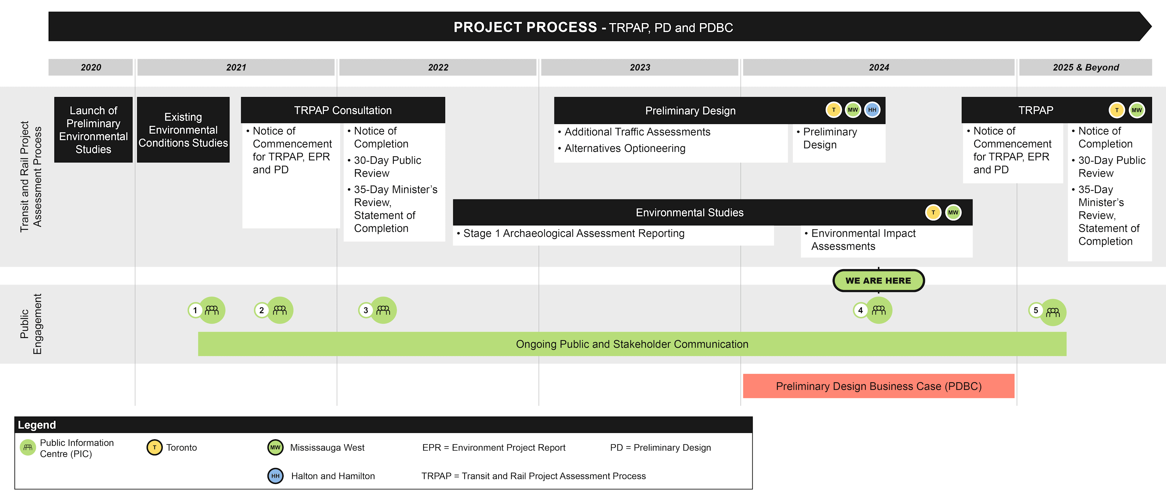
What formal process is followed?
Metrolinx is working with various municipalities to advance planning and design of the Dundas BRT Project, which includes the following key phases:
- TPAP
- Preliminary Design (PD)
- PDBC
Service Options Analyzed in The Initial Business Case
The Dundas BRT Initial Business Case considered the following three service options. All the options perform well and show a robust case for investment, demonstrating the benefits of service integration on the Dundas corridor to support BRT infrastructure investment.
Concept 1: Through running service
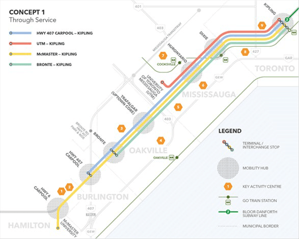
A set of east-west running BRT services that typically originate north or south of the corridor, with only some services terminating at the Kipling Transit Hub.
Concept 2: Segmented service
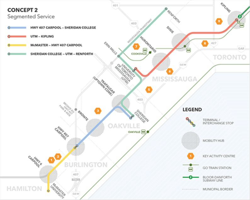
A set of east-west running BRT services that typically originate north or south of the corridor, with only some services terminating at the Kipling Transit Hub.
Concept 3: Overlapping services
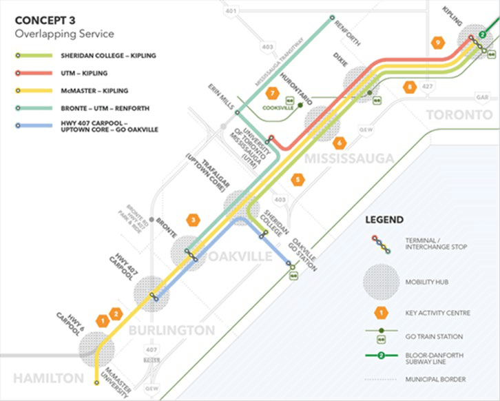
A combination of Concepts 1 and 2, with some services running the entire length of the corridor and other services connecting the corridor to locations north or south of Dundas Street.
Initial Business Case findings
In September 2020, Metrolinx completed and published an Initial Business Case (IBC) to assess the need for the Dundas BRT. The document provides an evidence-based assessment of the case for investment in the new rapid transit corridor. The IBC provides the information necessary for decision-makers, stakeholders and the public as an important part of the transparent and evidenced-based decision-making process.
This document includes:
- A confirmation of the problem and/ or opportunity and identifies a set of investments that could address them
- Provides a high-level range of varying investments that could be implemented
- Gives insights and recommendations for future work
The IBC evaluated the early-stage feasibility of the Dundas BRT by examining the strategic, economic, financial and deliverability and operations cases. The IBC found that the BRT could:
- Accommodate more than 30,000 new net daily riders
- Benefit traffic flow resulting in between 345,000 and 555,000 hours of decongestion benefits per year
- Decrease greenhouse gas emissions by between 100,000 to 600,000 tonnes per year
- Unlock economic and regional development by connecting rapid transit to 230,000 to 465,000 jobs found within 2 kilometres of the catchment area (approximately a 10-minute walk)
- Offer frequent rapid transit service to 600,000 to 1,000,000 people living within 2 kilometres of the corridor
- Reduce transit commute times along the corridor by approximately 14 minutes on average
Development
Unlock economic and regional development along the corridor with 230,000 jobs within a 2 km radius
Ridership
Attract new ridership (~31,000 new riders per day)
Connectivity
Improve connectivity by connecting to other transit services operating along Dundas Street corridor
Quality of life
Improve quality of life by allowing 660,000 people living within a 2 km radius to go where they want to go
Key destinations
Provide key connections to Kipling Transit Hub and Etobicoke and Mississauga City Centres, plus access to key destinations along Dundas Street*
*Key destinations along Dundas Street such as:
- Residential and commerical areas;
- Educational institutions;
- Places of worship;
- Medical institutions;
- Parks and outdoor recreation; and
- Dining, entertainment and shopping destinations
The studies
Natural environment
Study Method
Methods undertaken to complete these studies include the following:
- Examine designated natural areas and planning policy areas.
- Vegetation community and plant inventories.
- Fish and fish habitat surveys.
- Wildlife and wildlife habitat surveys.
- Significant wildlife habitat and species at risk screening.
- Identify potential adverse effects and appropriate mitigation measures.
Existing environmental conditions
Toronto
- The only natural vegetation community within the study area was identified along the forested banks of Etobicoke Creek. The forested ravines of Etobicoke Creek likely act as important wildlife corridors, allowing for the movement of wildlife between areas to seek food, shelter and mates within the City of Toronto’s Natural Heritage System.
- No vegetation communities were identified as, or anticipated to be, provincially significant.
- The fish community that inhabits Etobicoke Creek is primarily cool-warm water species that are tolerant of disturbances.
- The majority of the wildlife are common in the City of Toronto and are tolerant to disturbances, while a small proportion is comprised of sensitive or rare species.
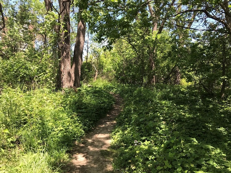
Recreational trail in Toronto. Source: AECOM, 2021.
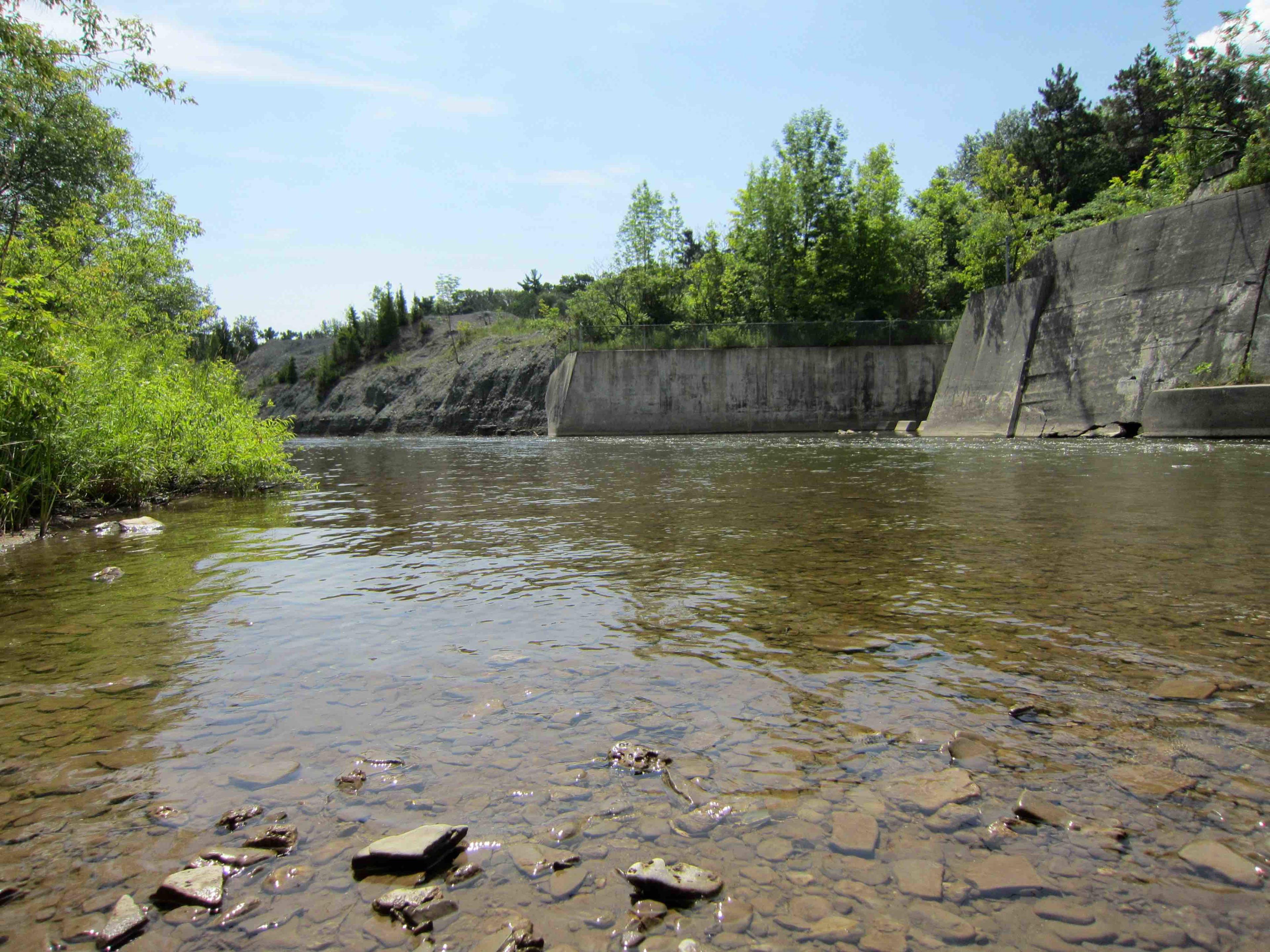
Mississauga East
- The study area includes a variety of urban, residential and industrial areas which are divided by several natural features including watercourses, riparian areas and vegetated corridors.
- Several watercourses cross the study area and provide habitat to a variety of fish species including Sawmill Creek, Glen Erin Brook (coolwater systems) and Etobicoke Creek, Little Etobicoke Creek and Cooksville Creek (warmwater systems).
- A wide variety of migratory birds nest within the study area and Cliff Swallows, Barn Swallows, Eastern Phoebe and American Robin were identified under the Etobicoke Creek bridge.
- Species at Risk are known to occur within the study area including: Barn Swallow, Chimney Swift and Snapping Turtle.
- Local wildlife corridors exist in several areas, primarily associated with watercourse, riparian areas and valley lands for small, medium and large mammals as well as turtles.
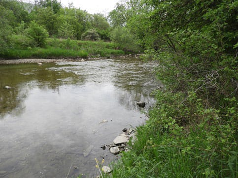
View of Etobicoke Creek looking downstream (south) from the bridge structure. A riffle exists downstream of the structure. Source: AECOM, 2021.
Mississauga West
- The study area includes a variety of urban, residential and industrial areas which are divided by several natural features including watercourses, riparian areas and vegetated corridors.
- Crossing the study area, Mary Fix Creek and the Credit River provide habitat to a variety of fish species, with the Credit River also providing migratory corridors for populations of salmon and trout.
- Several natural heritage features are found within the study area, including the Credit River at Erindale Areas of Natural and Scientific Interest (ANSI) and Erindale Park near the Credit River.
- A wide variety of migratory birds nest within the study area.
- Species at Risk are known to occur within the study area, including Barn Swallow, Chimney Swift and Snapping Turtle.
- Local wildlife corridors exist in several areas primarily associated with watercourse, riparian areas and valley lands for small, medium and large mammals as well as turtles. Several other wooded areas within the study area also provide corridors for bats, including the Big Brown Bat.
View of the Credit River flowing through Erindale Valley. Source: AECOM, 2021.
Traffic & Transportation
Study Method
The purpose of the environmental studies are to:
- Establish existing (baseline) conditions;
- Identify and characterize existing features;
- Complete impact assessments; and
Develop measures to avoid, minimize or mitigate potential negative effects.
Methods undertaken to complete these studies include the following:
- Review all transportation infrastructure and services in the study area, including roadways, intersections, highway interchanges, transit routes, cycling lanes, sidewalks and multi-use paths.
- Assess available traffic, cyclist and pedestrian count data.
- Simulation modelling of the corridor to assess intersection operating conditions and auto and transit bus travel times.
- Identify traffic bottlenecks, poor intersection performance, transit delay points and other impacts to transportation and traffic operations.
- Testing, modelling and recommendation of mitigation measures to improve performance.
Existing Environmental Conditions
Toronto
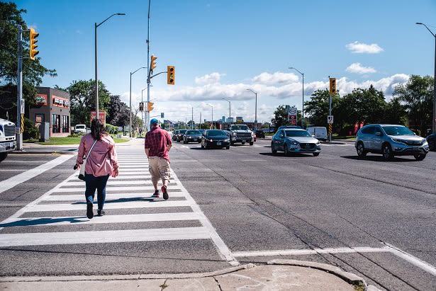
- Within Toronto, Dundas Street has a six-lane cross-section with a centre two-way left-turn lane providing access to many side streets and private driveways. The curbside traffic lane is designated as a high occupancy vehicle lane in both directions, permitting only transit vehicles, taxis and personal vehicles with occupancy of three persons or more for designated time periods.
- Sidewalks are provided on either side of Dundas Street, with no dedicated cycling facilities provided.
- Generally heavier volumes during the afternoon peak hours as compared to those in the morning peak hours. The largest directional traffic volumes along Dundas Street are 1,900 vehicles in the morning peak hour and 2,100 vehicles in the afternoon peak hour.
- All intersections with major arterial roads operate at acceptable levels of service in both the morning and afternoon peak hours.
- In both the morning and afternoon peak hours, the most congestion occurs at intersections near the Highway 427 interchange and near Kipling Transit Hub due to high volumes of local buses accessing the terminal.
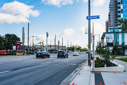
Vehicular traffic travelling eastbound on Dundas Street at Auckland Rd, near Kipling Station in Toronto. Source: AECOM, 2021.
Mississauga East
- Within the Mississauga East corridor, Dundas Street varies between six- and four-lane cross-sections, and in many locations a centre two-way left-turn lane is present. A curbside high occupancy vehicle traffic lane is provided between Dixie Road and Etobicoke Creek.
- Continuous sidewalks are provided on both sides of Dundas Street within Mississauga East, with no dedicated cycling facilities provided.
- Generally heavier volumes during the afternoon peak hours as compared to those in the morning peak hours. The largest directional traffic volumes along Dundas Street are 1,800 vehicles in the morning peak hour and 2,200 vehicles in the afternoon peak hour.
- Most intersections operate at acceptable levels of service in both the morning and afternoon peak hours. However, in both the morning and afternoon peak hours, congestion occurs in Cooksville near the Hurontario Street intersection. Other intersections with major arterial roadways, like at Dixie Road, operate with poor levels of service in the peak hours.
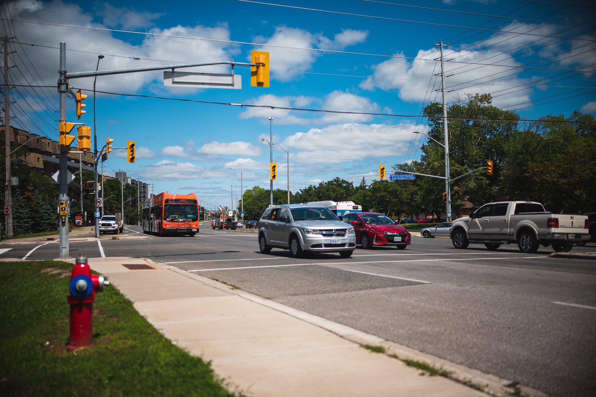
Vehicular traffic travelling westbound on Dundas Street at the Dixie Road intersection in Mississauga. Source: AECOM, 2021.
Mississauga West
- Within the Mississauga West corridor, Dundas Street varies between six- and four-lane cross-sections, and in many locations a centre two-way left-turn lane is present.
- Continuous sidewalks are provided on both sides of Dundas Street within Mississauga West, with no dedicated cycling facilities provided.
- The largest directional traffic volumes along Dundas Street are 3,000 vehicles in the morning peak hour and 2,100 vehicles in the afternoon peak hour.
- Most intersections operate at acceptable levels of service in both the morning and afternoon peak hours.
- In both the morning and afternoon peak hours, the most congestion occurs west of Winston Churchill Boulevard. Other intersections with major arterial roadways (Mavis Road, Winston Churchill Boulevard, and Erin Mills Parkway) operate with poor levels of service in the peak hours.
Vehicular traffic travelling westbound on Dundas Street at The Credit Woodlands intersection in Mississauga. Source: AECOM, 2021.
Air quality
Study Method
Methods undertaken to complete these studies include:
- Examining vehicle exhaust and greenhouse gas emissions (GHGs). The assessment was based on publicly available historical data from ambient air quality monitoring stations close to the study area.
- Five-years of data, averaged to capture existing air quality data from monitoring stations. Emissions captured included: vehicular emissions, diesel rail emissions, and industrial emissions.
o Vehicular emissions;
o Diesel rail emissions; and
o Industrial emissions.
- Identifying potential adverse impacts, determine the need for mitigation and provide a strategy or list of potential mitigation measures based on construction and operation plans.
Existing Environmental Conditions
Toronto
- Background air quality levels are predominately below respective provincial and federal ambient air quality criteria and standards; however, some levels show significant exceedances, including:
o Benzo(a)pyrene;
o Benzene; and
o Nitrogen dioxide.
- Contaminants showing higher levels of background concentration above 80% of the federal standards include nitrogen dioxide and fine particulate matter (PM2.5).
- Meteorological data from the Toronto Pearson Airport over a five-year period (2016 – 2020) shows predominant wind direction blowing from northwest, west and southwest, and low-speed wind predominance from the southeast.
Mississauga East
- Background air quality levels are predominately below respective provincial and federal ambient air quality criteria and standards; however, some levels show existing exceedances, including:
o Benzo(a)pyrene;
o Benzene; and
o Nitrogen dioxide.
- Contaminants showing higher levels of background concentration above 80% of the federal standards include nitrogen dioxide and fine particulate matter (PM2.5).
- Meteorological data from the Toronto Pearson Airport over a five-year period (2016 – 2020) shows predominant wind direction blowing from northwest, west and southwest, and low-speed wind predominance from the southeast.
Mississauga West
- Background air quality levels are predominantly below respective provincial and federal ambient air quality criteria and standards; however, some contaminants show exceedances, including:
o Benzo(a)pyrene;
o Benzene; and
o Nitrogen dioxide.
- Contaminants showing higher levels of background concentration above 80% of the federal standards includes particulate matter (PM2.5).
- Meteorological data from the Toronto Pearson Airport over a five year period (2016 – 2020) shows predominant wind direction blowing from northwest, west and southwest, and low-speed wind predominance from the southeast.
Socio-Economic & Land Use Characteristics
Methods undertaken to complete these studies include the following:
- A desktop review using provincial and municipal documents and policies, online data sources such as the City of Mississauga Open Data Catalogue and associated databases/mapping tools.
- Site visits to supplement background research. The features examined include:
- Physical neighbourhood composition – land use and built form patterns, transportation network, and public realm characteristics;
- Community amenities – institutional uses, parks and recreational uses, community groups and resources;
- Neighbourhood demographics; and
- Future development.
Identify potential adverse impacts and opportunities respecting socio-economic features and land use.
Identify appropriate mitigation measures and monitoring requirements for potential adverse impacts.
Existing environmental conditions
Toronto
- The Toronto corridor is consistent with provincial and municipal plans and policies as it is anticipated to enhance public transit connections and support economic development objectives.
- Much of the study area directly fronting Dundas Street in Toronto, consists of low- to high-rise commercial and residential uses, with low-rise residential and commercial behind. High-rise development in the eastern end of the study area is clustered near the Kipling Transit Hub.
- A range of community amenities (including institutional and recreational uses, and community resources) are present within the study area. Most community amenities are clustered throughout the eastern end of the study area.
- Several development applications are either in progress or recently approved within the study area. They primarily consist of new residential development.
- The demographic profile within the study area is relatively consistent with the Toronto city-wide average.
Mississauga East
- Mississauga East is consistent with provincial and municipal plans and policies as it is anticipated to enhance public transit connections to various communities and support economic development objectives.
- Land uses on Dundas Street in Mississauga East consist of low- and mid-rise commercial and residential uses, with low-rise residential and commercial behind.
- The demographic profile ranges within the study area, with some communities being relatively consistent with the Mississauga city-wide average whereas others differ.
- A range of community amenities (including institutional and recreational uses, and community resources) are present within the study area. Many of the community resources are clustered around Downtown Cooksville.
- Several development applications for various land use types are either in progress or recently approved within the study area.
Mississauga West
- Mississauga West is consistent with provincial and municipal plans and policies as it is anticipated to enhance public transit connections to the area and support economic development objectives.
- Land uses directly fronting Dundas Street consists of low- and mid-rise commercial and residential uses, with low-rise residential and commercial behind.
- A range of community amenities (including institutional and recreational uses, and community resources) are present within the study area. Erindale Park is a key destination for Mississauga residents.
- Several development applications for various land use types are either in progress or recently approved within the study area.
- The demographic profile within the study area is relatively consistent with the Mississauga city-wide average.
Cultural Heritage
Methods undertaken to complete these studies include the following:
- Historical research.
- Review heritage registers and inventories.
- Identify cultural heritage resources.
- Identify potential adverse impacts and appropriate mitigation measures.
Existing environmental conditions
Toronto
- There are no built heritage resources or cultural heritage landscapes within or adjacent to the study area and therefore, no adverse project impacts to cultural heritage resources are anticipated.
Mississauga East
- Seventeen built heritage resources and cultural heritage landscapes have been identified within the project area boundaries.
- A preliminary impact assessment will be completed to identify project impacts on the built heritage resources and cultural heritage landscapes.
- Mitigation measures and monitoring activities will be developed in the Cultural Heritage Report: Existing Conditions and Preliminary Impact Assessment.
Mississauga West
- Twenty-three built heritage resources and cultural heritage landscapes were identified within the project area boundaries.
- A preliminary impact assessment will be completed to identify project impacts on the built heritage resources and cultural heritage landscapes.
- Mitigation measures and monitoring activities will be developed in the Cultural Heritage Report: Existing Conditions and
- Preliminary Impact Assessment.
Noise & Vibration
Methods undertaken to complete these studies include the following:
- Identify receptor locations applicable for construction and operation.
- Assess construction and operation noise and vibration at receptors.
- Identify potential adverse impacts, determine the need for mitigation and provide a strategy or list of potential mitigation measures based on construction and operations plans.
Existing environmental conditions
Toronto
- The Toronto segment is generally a mix between commercial and residential uses in a busy suburban environment.
- Dundas Street is an arterial roadway that is intersected by other major corridors (e.g., Kipling Avenue and Highway 427) and minor residential or commercial access roads.
- Ambient sound levels at most impacted noise sensitive locations (e.g., dwellings) are dominated by a combination of existing Dundas Street and intersecting roads.
- Kipling station and the existing rail line is within approximately 300 m of sensitive locations but significant shielding from existing buildings lessens the noise contribution to the ambient sound level at sensitive locations.
- Currently, no known existing vibration concerns due to road traffic.
Mississauga East
- The Mississauga East segment is generally a mix between commercial and residential uses in a busy urban environment.
- Dundas Street is considered an arterial roadway which is intersected by other arterials (e.g., Dixie Road) and minor residential or commercial access roads.
- The ambient sound levels at the most impacted noise sensitive locations (e.g., dwellings) are dominated by a combination of existing Dundas Street and the intersecting roads.
- Existing GO rail intersecting Dundas Street near Cawthra contributes to the existing ambient sound levels at sensitive locations.
- Currently, no known existing vibration concerns due to road traffic. However, heritage buildings have been identified in close proximity to Dundas Street
Mississauga West
- The Mississauga West segment is generally a mix between commercial and residential uses in a busy urban environment.
- Dundas Street is considered an arterial roadway which is intersected by other arterials (e.g., Mavis Road) and minor residential or commercial access roads.
- Ambient sound levels at most impacted noise sensitive locations (e.g., dwellings) are dominated by a combination of existing Dundas Street and intersecting roads.
- Currently, no known existing vibration concerns due to road traffic. However, heritage buildings have been identified near Dundas Street.
Archaeology
Methods undertaken to complete these studies include the following:
- Visual inspection.
- Examine historical and archaeological data, including:
Recent and historical study area maps;
Previous archaeological assessments within 50 metres of the study area;
The Ministry of Heritage, Sport, Tourism and Culture Industries (MHSTCI) Archaeological Sites Database; and
Archaeological management plans or other archaeological potential mapping, where available.
Identification of potential adverse impacts and appropriate mitigation measures.
Existing environmental conditions
Toronto
- Three registered archaeological sites were identified within one km of the current project area boundaries.
- A visual inspection to confirm areas of archaeological potential versus areas of urban disturbance found that the project area consists primarily of residential and commercial development along Dundas Street West from the Toronto/Mississauga boundary at Etobicoke Creek to just west of Highway 427. The inspection also found that some areas may retain archaeological potential, requiring a Stage 2 archaeological assessment to confirm disturbance or search for archaeological materials.
- Results of the Stage 1 background research and field review, including mapping and determination of archaeological potential will be summarized in the Stage 1 archaeological assessment report.
Mississauga East
- Three registered archaeological sites were identified within one km of the current project area boundaries.
- A visual inspection to confirm areas of archaeological potential versus areas of urban disturbance found that the project area consists primarily of residential and commercial development along the Dundas Street East corridor, roadways and highways (e.g., Confederation Parkway, Hurontario Street and Dixie Road), with some areas of manicured lawn and park land.
- Results of the Stage 1 background research and field review, including mapping and determination of archaeological potential, will be summarized in the Stage 1 archaeological assessment report.
Mississauga West
- Eleven registered archaeological sites were identified within one km of the current project area boundaries.
- A visual inspection to confirm areas of archaeological potential versus areas of urban disturbance found that the project area consists primarily of residential and commercial development along the Dundas Street East corridor, roadways and highways (e.g., Highway 403, Erin Mills Parkway, Winston Churchill Boulevard and Mavis Road), with some areas of manicured lawn and park land.
- Results of the Stage 1 background research and field review, including mapping and determination of archaeological potential, will be summarized in the Stage 1 archaeological assessment report.
Climate Change & Sustainability
Methods undertaken to complete these studies include the following:
- Review background information.
- Determine project effects on climate change by completing a greenhouse gas inventory of existing conditions and the result of implementing the project (including construction, operation and maintenance).
- Determine effects of climate change on the project by completing a Climate Change Risk Assessment based on the International Organization for Standardization 31000 Risk Management Standard.
- Highlight Metrolinx’s current and planned sustainability initiatives in relation to project construction and operation, with the goal of improving environmental and social outcomes.
- Prepare a Climate Change and Sustainability Report.
Existing environmental conditions
- A Greenhouse Gas Inventory is being developed that incorporates the emissions during construction and operations and will include the resulting mode shift as a result of the entire Dundas BRT.
- The application of Metrolinx’s broader sustainability initiatives currently underway will be included in the design, construction and operation of the Dundas BRT with the goal of improving environmental and social outcomes. In addition, recommendations will be made to reduce greenhouse gas emissions along the corridor.
Toronto
- Dundas Street is subjected to riverine flooding within Toronto at Etobicoke Creek, which will be included in the Risk Assessment.
Mississauga East
- Dundas Street is subjected to riverine flooding, which will be included in the Risk Assessment. The major area of riverine flooding in Mississauga East occurs at Etobicoke Creek.
Mississauga West
- Dundas Street is subjected to riverine flooding, which will be included in the Risk Assessment. The major areas of riverine flooding in Mississauga West occur at the Credit River.
Special Policy Area (SPA) Studies
How are SPA studies different from the Transit Project Assessment Process (TPAP)?
As the TPAP assesses the impacts and determines the proposed mitigation measures of the structure replacements proposed at Etobicoke Creek and Little Etobicoke Creek crossings, the SPA studies capture the proposed works for the watercourse channels and elsewhere within the floodplain.
What’s happening now?
Coordination with the following City of Mississauga SPA studies has progressed to ensure that the Etobicoke Creek and Little Etobicoke Creek crossings are coordinated to meet the goals and objectives of both the Dundas Bus Rapid Transit (BRT) and SPA studies:
- Dixie-Dundas Flood Mitigation EA Study (Little Etobicoke Creek SPA)
o A short-list of conceptual culvert replacement options was developed.
o Preliminary design was developed spring 2022.
- Etobicoke Creek SPA Feasibility Study
o Hydraulic Analysis completed.
o Confirmation that existing structure has sufficient hydraulic capacity.
Dundas Street widening
Dundas Street will be widened in certain areas to accommodate the proposed BRT lanes and facilities, including four general purpose traffic lanes, cycling facilities, wider sidewalks, and amenity space for utility poles, trees and street furniture.
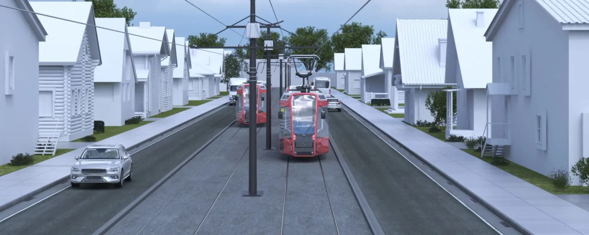
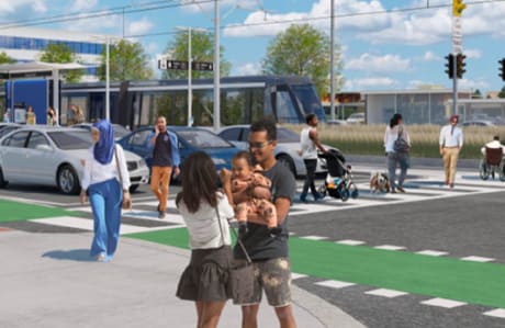
Cross section street renderings
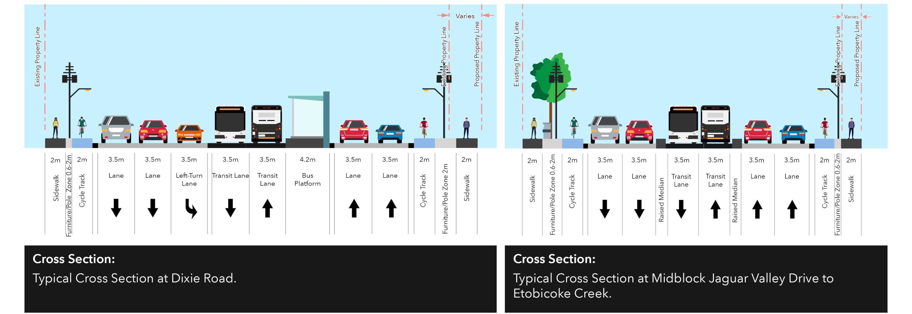
Cross Section: An example of curbside BRT with reserved bus lanes on Dundas Street
Cross section outside pinch point
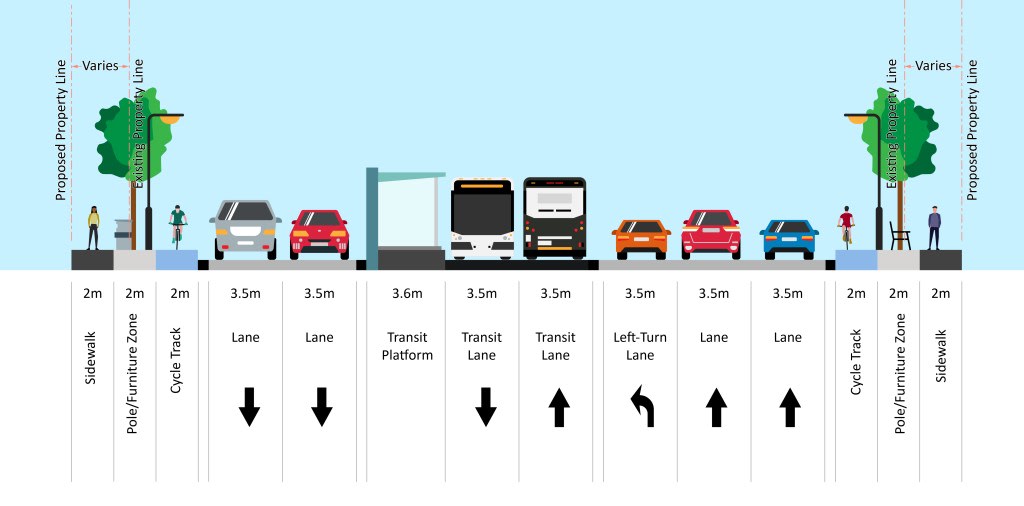
Cross Section: An example of median BRT on Dundas Street
Dundas BRT pinch points